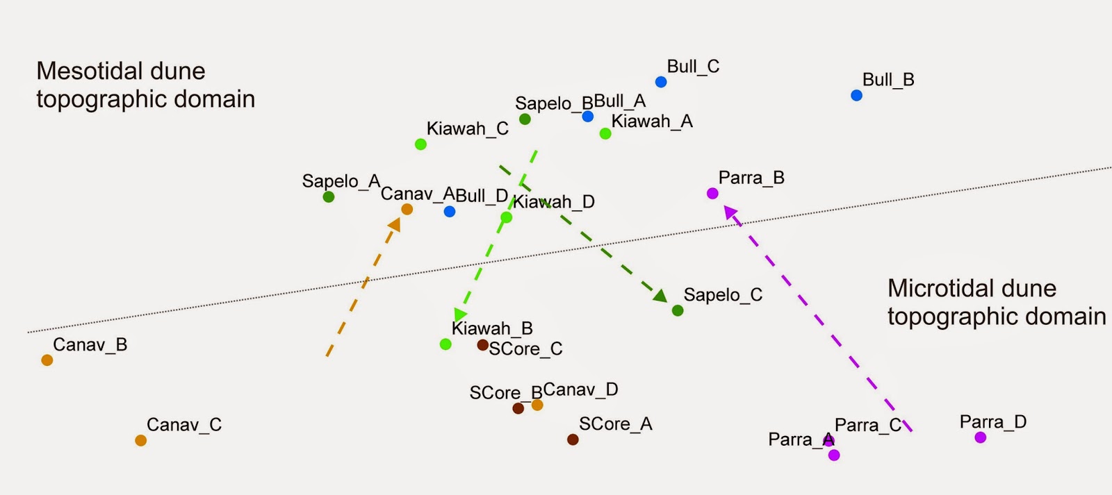
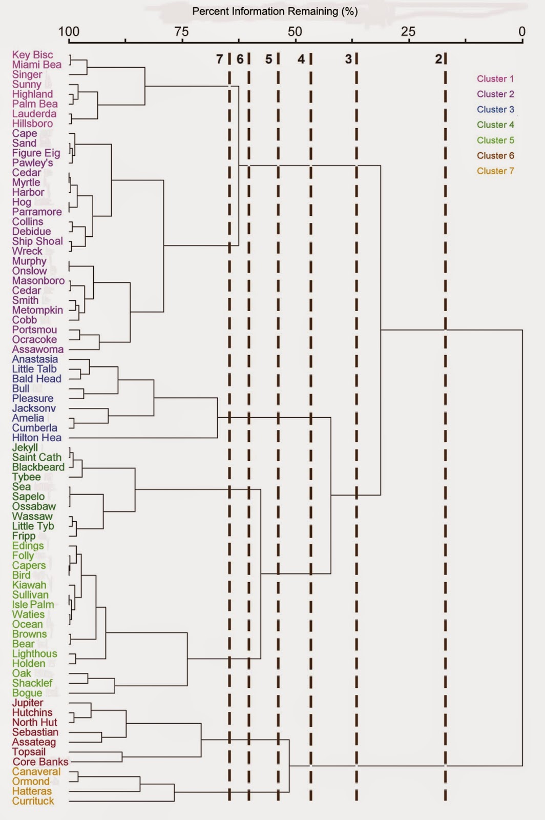
My graduate student Jackie Monge recently completed a thesis that examined the similarities in dune topography among different barrier island morphologies. We found that dune topography tends to converge around two basic forms (top graphic), an overwash-reinforcing topography associated with microtidal barrier island dune topographies. and an overwash resisting topography characteristic of mesotidal barrier islands. This convergence held up over a range of cluster groupings of barrier island morphology (middle graphic). Dune topography was compared on the basis of lidar-derived indices of landscape patch structure of elevational ranges, directional spatial autocorrelation structure of elevation, and frequency distribution data for elevation (bottom graphic, lidar for a site on Sapelo Island). Her thesis can be accessed here.
Thursday, August 28, 2014
Severe thunderstorm warning bias
One of my master's students Megan White recently completed her thesis on the relationship between the issuance of severe thunderstorm warnings and underlying demographic variables. The map above shows the distribution of National Weather Service severe thunderstorm warnings. Each grid cell represents the number of severe thunderstorms issued over the five years of the study. Megan's thesis can be accessed here. |
Wednesday, August 20, 2014
Results of urban pollen monitoring pilot study
Saturday, August 16, 2014
Pollen monitoring in urban apiary
Photos documenting a pilot study I conducted with the beekeepers who run the 5th Street Apiary here in Lexington during summer 2013. This work is part of project I have been incubating for several hundred years. The only thing lacking now is a student who would be interested in expanding it for a thesis or dissertation. The study I have been envisioning examines relationships between pollen composition collected by honey bees, its nutritional content (as measured by amino acids), and surrounding land uses. Here is a summary of a recent NSF proposal submission.
This photo at left shows the iButton temperature probe we installed in the hives to track the internal temperatures.
These are the colonies monitored for a period of two months. On the front of each hive trimmed in yellow paint are the pollen traps. They collect pollen off the foraging bees as they return to the hive.
Friday, August 15, 2014
Paint pole dune topographic mapping
We recently tried out a paint pole-mounted camera as another method to derive topographic maps. We tested our methods in the dunes on a recent trip to Sapelo Island, GA. At the bottom is the video taken from our Canon Powershot D20. We used a paint pole purchased from Home Depot and camera mounting equipment sold by PolePixie. The video above is the raw video. We edited this video down and then removed the shakiness before extracting frames in Photomodeler. The resulting dense point cloud is shown above. The image still requires some post-processing to remove relief introduced by the vegetation, but all in all, the paint pole seems well suited to capture topography.
Kite topographic mapping - UK campus
Here are some of the results of our recent pilot work with kite photography and structure-from-motion topographic mapping. We were also able to tie in UTM coordinates to the surface we produced. Although not very visible in these photos at left, we established ground control points using chalk spray paint and our GPS. Our Trimble GEOXH gave us coordinates with 0.10 horizontal and 0.20 vertical accuracies after differential correction, which may not be that useful for the small extent and low contrasts in relief shown here.
I would like to continue refining our kite photography and SFM skills. However, there isn't enough time for me to explore this solely on my own. If you are an undergraduate or graduate student and want to do an independent study, thesis, or dissertation with these techniques, send me an email.
Field class trip to Sapelo Island, Georgia
Daehyun Kim (above) and Tony Stallins (below).
|
Coachwhip (Masticophis flagellum) in the rear dunes, estimated to be about 6 ft in length. |
Kite topographic mapping - Sapelo Island, Georgia
Subscribe to:
Posts (Atom)