| I started this online film list back in 1998. I had had a decade or so of heavy film viewing -- I worked my way through my master's degree by working at a video store in Atlanta, Movies Worth Seeing. I've put the page back up, as my film viewing is slowly increasing now that the twins are little older. |
 |
Wednesday, December 10, 2014
My movie list
Friday, October 24, 2014


Tuesday, October 14, 2014
Research opportunities - UK Department of Geography
Email me as ja.stallins@uky.edu
if you have any questions. Check out the rest of my blog for more detail about this research.
Honey bee pollen
foraging and land use. I’ve collected pollen from an urban apiary here in Lexington. I would
like to identify the pollen using standard light microscope protocols and assay
the pollen for amino acid composition to determine its nutritional quality. A
number of studies have commented on the higher diversity of plants in some
humanized landscapes, however, whether or not this pollen is of high or low
nutritional quality hasn’t been established. I’d work with you to learn some
basic pollen id. I’d love to
have someone interested in learning how to be a beekeeper and setting up a colony
in the spring. There’s a potential for some qualitative research – I would like
to have someone interview beekeepers regarding general issues they have
encountered regarding land use, land zoning, and finding forage for their honey
bees. Sadly, the political ecology aspects of beekeeping remain underdeveloped, and any of this work could easily become the basis of a master's thesis, dissertation, or an undergraduate research project.
Wildlife rehabilitation, race, and biodiversity. The analyses of this project are done. I’ve mapped the locations of where people live that brought injured animals to a wildlife rehabilitation center in Tallahassee, Florida – about 20,000 animals over a 7 year period. I used to geographically weighted regression to visualize who brings in these animals. There are a lot of points this work raises about race, class, and attitudes about wildlife. It also brings up the concept of incidental biodiversity – the biodiversity that is present but often undocumented except by chance encounter. I’d love to have someone take up some of the writing, or, replicate this project using wildlife rehabilitation data for our area in a thesis or PhD. It could be a good GIS learning experience if you were to replicate this project here in Kentucky.
Structure-from-motion photography. I am looking for someone to continue working with me on learning SFM. This involves using ground-based, paint pole, or kite-based photography to construct three-dimensional images. A friend of mine who works in stream restoration has given me the okay to come out sometime this January or February to map a work site of his. This project would be a good way to get some GIS and GPS experience; however, it’s like most on-the-fly work you do with GIS, sometimes you have to dig to figure out what button to push. I can get you started, but I have progressed to the point where I don't have enough time to refine the techniques.
LIDAR dune topography database construction. One of our PhD students is going to need some assistance constructing a database of topographic measurements from barrier islands along the Atlantic coast. You would learn how to download and set up lidar data sets and how to manipulate lidar data to get it into a format that we need for geostatistical analyses. There are several facets of this work that could easily become a master's thesis or undergraduate research project.
Barrier island dune
vegetation analysis. A field class I taught last spring travelled to Sapelo Island, Georgia in
May. We collected dune vegetation compositional data in a location that I had
sampled about fifteen years earlier. I’m looking for someone to analyze this
data under my guidance and make some statements about how the topography and vegetation has
changed. You would learn how to use a PC-Ord ecological software package and gain experience with the trench-level work of exploratory statistical analysis.
Thursday, August 28, 2014
Visualizing barrier island dune topographic state space
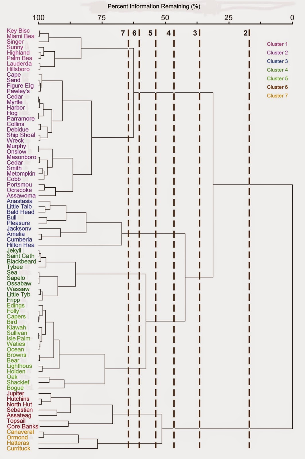
My graduate student Jackie Monge recently completed a thesis that examined the similarities in dune topography among different barrier island morphologies. We found that dune topography tends to converge around two basic forms (top graphic), an overwash-reinforcing topography associated with microtidal barrier island dune topographies. and an overwash resisting topography characteristic of mesotidal barrier islands. This convergence held up over a range of cluster groupings of barrier island morphology (middle graphic). Dune topography was compared on the basis of lidar-derived indices of landscape patch structure of elevational ranges, directional spatial autocorrelation structure of elevation, and frequency distribution data for elevation (bottom graphic, lidar for a site on Sapelo Island). Her thesis can be accessed here.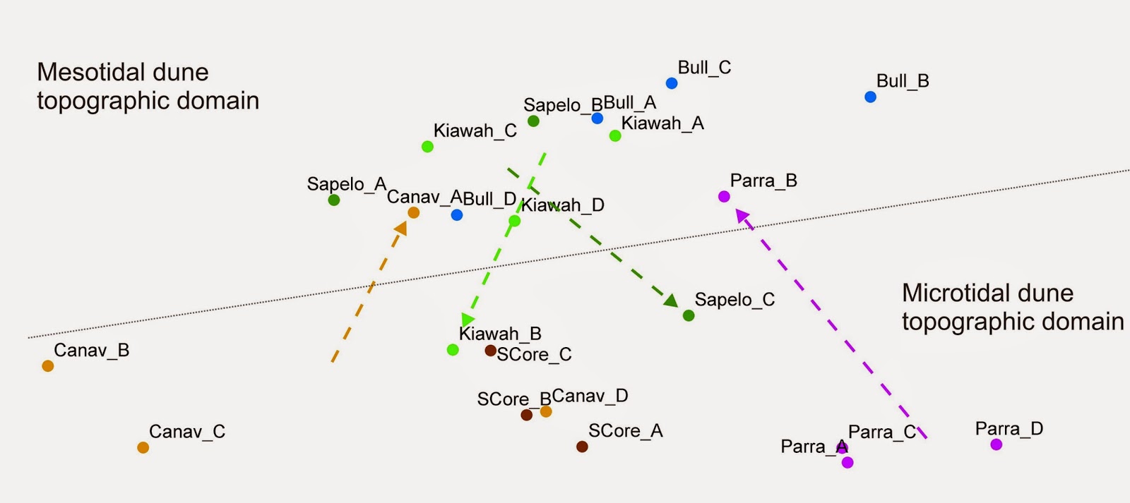

Severe thunderstorm warning bias
 |
| One of my master's students Megan White recently completed her thesis on the relationship between the issuance of severe thunderstorm warnings and underlying demographic variables. The map above shows the distribution of National Weather Service severe thunderstorm warnings. Each grid cell represents the number of severe thunderstorms issued over the five years of the study. Megan's thesis can be accessed here. |
 |
| In this map of local R2 derived from geographically weighted regression, one can see the varying relationship between the number of severe thunderstorm warnings and the properties of the underlying demographic template. Boundary lines are National Weather Service forecast zones. White and red shades indicate areas where there was a stronger association between demographic variables (population count, percent white, and median income) and severe thunderstorm warning issuance. Several cities stood out for their propensity to issue warnings that more frequently coincided with increasingly populated, whiter, higher income areas. Forecasters in Washington DC, Nashville, the Atlanta I-75 corridor, and St. Louis were more likely to to take into account these underlying demographic variables when alerting the public about severe weather. |
Wednesday, August 20, 2014
Results of urban pollen monitoring pilot study
 |
| Some of the pollen collected during this project. I have not yet had time to go back and identify the pollen. If you are interested in doing an independent study, thesis, or dissertation related to this work, let me know. |
 |
| Conceptual framework for a study of how land use, pollen forage, and beekeeping interact. The dashed line indicates the feedback linking back to land cover. As beekeeping becomes more difficult and pollination services more expensive or harder to procure for bee-dependent crops, more land may be converted to agriculture to make up for shortfalls in crop production. |
 | |||||||||||||
| Amino acid composition for the pollen collected from a colony at the 5th Street Apiary in Lexington, KY. Although these samples were collected approximately one month apart from the same hive, they show significant differences in the quantities of amino acids. The most essential amino acids for honey bees are isoleucine, leucine, and valine. HPLC chemical analyses were at UK in the Environmental Research Training Laboratory. |
Saturday, August 16, 2014
Pollen monitoring in urban apiary

Photos documenting a pilot study I conducted with the beekeepers who run the 5th Street Apiary here in Lexington during summer 2013. This work is part of project I have been incubating for several hundred years. The only thing lacking now is a student who would be interested in expanding it for a thesis or dissertation. The study I have been envisioning examines relationships between pollen composition collected by honey bees, its nutritional content (as measured by amino acids), and surrounding land uses. Here is a summary of a recent NSF proposal submission.
This photo at left shows the iButton temperature probe we installed in the hives to track the internal temperatures.

These are the colonies monitored for a period of two months. On the front of each hive trimmed in yellow paint are the pollen traps. They collect pollen off the foraging bees as they return to the hive.

Friday, August 15, 2014
Paint pole dune topographic mapping

We recently tried out a paint pole-mounted camera as another method to derive topographic maps. We tested our methods in the dunes on a recent trip to Sapelo Island, GA. At the bottom is the video taken from our Canon Powershot D20. We used a paint pole purchased from Home Depot and camera mounting equipment sold by PolePixie. The video above is the raw video. We edited this video down and then removed the shakiness before extracting frames in Photomodeler. The resulting dense point cloud is shown above. The image still requires some post-processing to remove relief introduced by the vegetation, but all in all, the paint pole seems well suited to capture topography.
Kite topographic mapping - UK campus

I would like to continue refining our kite photography and SFM skills. However, there isn't enough time for me to explore this solely on my own. If you are an undergraduate or graduate student and want to do an independent study, thesis, or dissertation with these techniques, send me an email.


Field class trip to Sapelo Island, Georgia
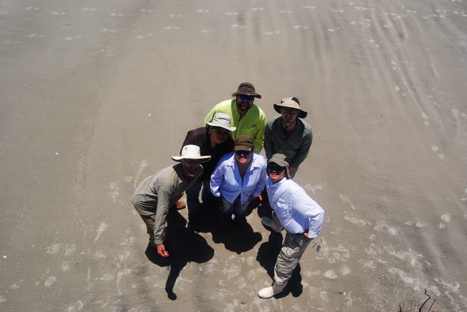
 |
| GEO 721 Field class on ferry to Sapelo Island (above). Video of class (top) taken surreptitiously with our paint pole. Below, from left to right, Tony Stallins, Li-Chih Hsu, Jackie Monge, Shelby Jones, Alex Rittle, and Daehyun Kim. |
 |
Daehyun Kim (above) and Tony Stallins (below).
 |
 |
| Coachwhip (Masticophis flagellum) in the rear dunes, estimated to be about 6 ft in length. |
Kite topographic mapping - Sapelo Island, Georgia
 |
| (Above and below) In May, my GEO 721 field class traveled to Sapelo Island Georgia to try out kite photography in the coastal environment. We were using a Canon Powershot camera for video and still photography. For an idea of what our kite looks like visit the web page for Allsop Helikites. The view above is looking north on Nannygoat Beach, just above the beach entrance off Old Beach Road. |

 |
| We are using Photomodeler software to create topographic maps derived from photos and video. The image above was processed in Photomodeler using stills from the video at selected intervals. Because of high wind speeds on the day we flew the kite, our camera mount did not stay in position and we ended up with less than desirable oblique angle photos. However, reconstructing the topography from the image was still feasible. Below is the raw video of our flight. We stabilized segments of the video using ProDrenalin software before structure-from-motion reconstruction. |
Subscribe to:
Posts (Atom)